


Kingston Under the Ground: The town beneath the grass

Kingston Under the Ground: Some glimpses of the town beneath the grass
The Kingston we see today is mainly the official town of the 1830s and 1840s, but it overlays the older 18th century town of Sydney Bay, as well as abandoned quarters of the 19th century town that are now little known.
The grand buildings and avenues of Kingston indicate the scale of the public works in the 1830s and 1840s that could be achieved with unlimited and well skilled convict labour. It also tells us something about the commandants and their vision for the town and its future, and about the larger colonial and national forces that have shaped Norfolk Island’s history since 1788.
Kingston’s history has been dominated, in the recent past, by horror stories of the gallows, whip and lash, but archaeology can reveal to us another story, of men and women and children who have been born, lived and died here, struggled and laughed, been good and been bad, of a living community that can still be experienced.
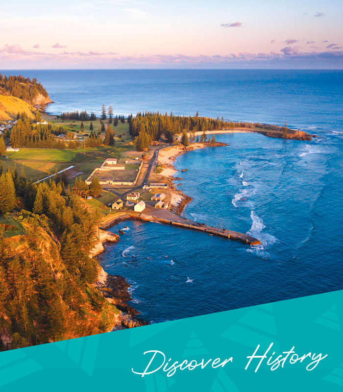
The Town on Sydney Bay
The old town was born on 6th March 1788 when a party of convicts, officials and soldiers landed on the sandy shore, erected their tents and claimed the island for King George III. For the first few years it was called Sydney or Sydney Bay, after the bay that it faces. Under the leadership of Lieutenant Governor Philip Gidley King RN, the town began to develop in a way that reflected many other coastal villages on rocky shores that the settlers were familiar with. Although King had been born and raised in the Cornish town of Launceston, some 20 kilometres from the sea, his layout of the settlement reflected his English origins. Just as Launceston was dominated by a castle on a hill, so the Government Houses of 1788 and 1792 were sited on a ridge overlooking the landing place and the roads that eventually lead inland to Ball Bay, Queensborough and Philipsburg, as well as keeping the whole settlement in view.
The Old Town was fairly compact, with the principal buildings in the area between the landing place and Government House along St George’s Street and Cascade Street (now Pier Street), and a hospital and several cottage-lined lanes, including Sirius Street and Cook’s Street, running off Church Street (now Bay Street) in the area now covered by the New Gaol ruins. A major change to the town took place in 1804 when the third (and present) Government House was built on Dove’s Plot Hill, well away from the town but still close enough for its presence to be visible to any of the townsfolk.
As the town developed between 1788 and 1814, its growth occurred in two main phases. The town really took shape around the landing place and along the beach between 1788 and 1796 under King. The first courthouse, gaol, school, and church were located in this area. In 1790 a hospital and hospital garden was built at the end of the cottage rows, between the beach and the swamps, and a year or so later lime burning had begun in the Chimney Hill area. This established the town’s east end as the industrial quarter around the canal built in 1795. It ran around the back of Chimney Hill to drain the swamplands. On the other side of the canal the Burying Ground was in place by 1796, marking the eastern limits of the town.
A second wave of building between 1800 and 1804 under Lieutenant Governor Joseph Foveaux of the New South Wales Corps produced a stout Gaol near the landing place and the present Government House (now the oldest operating vice-regal residence in the Commonwealth of Nations), as well as a number of new roads, bridges and seawalls, and a wooden-piped water supply to the town. New lime kilns were built in 1802 to provide lime for further building works. He also had instructions to build those essential 18th century welfare institutions, an orphan school and a workhouse, although it is not clear whether either was ever built. After Foveaux’s departure, there was little new building work as arguments flew between Sydney and London over whether to close down or further develop the island.
Eventually the decision to close the island was made, and despite delays and dogged resistance from the settlers they were all eventually removed, and the darkest days of the town, which was by then known as Kings Town, came in the late summer of 1814. A gang of thirty convicts and their guards rounded up the last of the stock, and killed and salted them for the deported settlers. The last two remaining settlers, Thomas Ransom and William Hutchinson, then had to set the whole town ablaze. As they sailed away on the Kangaroo on the 28th February 1814 from Sydney Bay for Port Jackson they left behind a smoking and silent town, populated only by the dogs that had been left behind to devour any remaining stock.
For the next eleven years the ruined town lay abandoned, although occasionally visited by passing whalers looking for water, and was even rumoured to be a haven for pirates.
When the convicts and soldiers returned in 1825, the town was covered by grass over two metres high growing among the chimneys and other ruins of the stone buildings. Captain Turton of the 40th (2nd Somersetshire) Regiment reported back to Sydney that the town, although largely in ruins, retained plenty of stone buildings that could be restored, even for temporary uses. The convicts included a group of mechanics from Port Macquarie, brought over for their building skills who were quickly put to work rebuilding the town.
Arthur’s Vale was Kingston’s first country district, being used for growing food from the early months of 1788. Field boundaries, altered creek channels, re-routed roads and the ruins of several buildings survive in the archaeological layer of the valley.
Many of the other buildings such as the old government houses, the school, the court house, and many of the cottages were originally built of timber or brick noggin and not rebuilt. They survive, however, in an extensive archaeological layer just beneath the current land surface around the Pier and around Chimney Hill. Car parking is restricted in the old St George’s Street area (now a grassy field west of the Crankmill), and around the old lime kilns, to protect this fragile resource from compression. In both places fragments still come to the ground surface after rain, and bumps and depressions in the ground surface signal the ghosts of the old town below the grass.
The Old Town is one of Australia’s most significant archaeological sites. Along with Sydney and Parramatta it is one of the three 1788 towns. It is a birthplace of the nation, and of European settlement in the South Pacific.
The backways of the New Town
The canal had been built to drain the Kingston Swamps in 1795, but it was in the 1830s that the first serious attempts were made to drain and manage the wetlands. Lieutenant Colonel James Morisset of the 48th (Northamptonshire) Regiment commanded the penal establishment between 1829 and 1834. He lived in the restored 1804 Government House with his wife Emily and five young children, three of them born in the house, and was responsible for constructing much of the creek channel along its present straight alignment and the earliest of the bridges.
Morisset’s successor as Commandant,Major Joseph Anderson of the 50th (Queen’s Own) Regiment, and a veteran of the Napoleonic Wars in Spain, transformed the marshlands into a picturesque domain for Government House. Anderson lived in Government House with his wife Mary, and six young children. Major Anderson is to Kingston what Sir Christopher Wren is to London or Walter Burley Griffin is to Canberra. His name adorns the pediments and plaques of several of the new town’s principle buildings. Anderson introduced a scheme to transform the marshlands into a classical Arcadian setting for the vice-regal residence.
The area that is now the Kingston Oval was laid out about 1835 as an extensive parterre garden called ‘The Boulevards’, with the creek diverted through a curving channel called ‘the Serpentine’ that, after flowing beneath several bridges passed through a grotto-like tunnel cut through the middle of Chimney Hill and into the re-built canal. The channels were lined with loose coral stone rubble, and a timber sluice gate beside Old Bay Street Bridge maintained a constant water level in the Serpentine. The military and civil officials and their ladies promenaded through the gardens on summery evenings, while convict gardeners laboured through the day to maintain this reminder of metropolitan glamour and sophistication. Bligh Street separated the public gardens from the vice-regal domain.
Anderson left the Island in 1839, and his successor, Major Thomas Bunbury of the 80th (Staffordshire Volunteers) Regiment, instituted a more ‘practical’approach to penal administration. He considered the serpentine to be a sewer made to “fetidly meander” through the gardens, which he converted into sporting fields “for athletic pastimes and exercises such as cricket, quoits, bowls and footballs” that are still in use today.
He also demolished Irish Town, a hamlet of huts behind the New Military Barracks where soldiers and convicts traded in stolen goods and especially the illicit tobacco that was widely grown across the Island and also smuggled by trading ships in the harbour. The quantities of clay pipes recovered from archaeological digs show the popularity of tobacco at this time. The soldiers at first refused to destroy Irish Town, and fronted Bunbury with loaded muskets but he coolly stared them down. The military were as rebellious as the convicts, and within months Bunbury and the regiment were withdrawn from the Island and sent to India. The clandestine bazaars of Irish Town, along with the formal parterre gardens and the romantic serpentine and grotto, receded into memory.
The creeks in Kingston are, to a large extent, convict-made drainage channels built by Morisset and Anderson to drain the marshes, and were often marked on 19th century maps as simply ‘drain’, without individual names. By the 1860s the Melanesian Mission clergy were blaming “the large drain choked up, a dry season, so that the swampy ground near the settlement has been dry…” for an outbreak of typhoid among the Pitcairners.
The Pitcairners inherited the terminology of drains from the convicts and adapted it for their own use. In modern Norf’k laengwij a watercourse or creek is known generically as a ‘drien’. Specific names such as Wortamil drien, Taun drien and Myuusik waeli (Watermill Creek, Town Creek and Music Valley) date from the late 19th to mid 20th century, and speak of a more modern age that could use reinforced concrete, machinery and paid workers to tame the marshlands.
After drainage works to control flooding in Kingston were completed in 1941 Anderson’s Arcadian landscape almost completely vanished, and the area was the driest it had ever been for the next fifty years until it was partly re-constructed in 1994-95 by the Kingston & Arthur’s Vale Historic Area Management Board. Archaeological investigations undertaken at that time revealed the extent of Anderson’s works and some of the stone bridgeworks can now been seen among the reeds and drienflaegs.
Protecting Kingston’s archaeology and artefacts
A number of archaeological investigations have been made in Kingston since the late 1970s, and the relics and artefacts recovered are now managed by the Norfolk Island Museum and mainly exhibited at the Commissariat Store Museum in Kingston. A 1983 excavation inside the Guardhouse, possibly the Old Town’s bakery dating from 1794, revealed seven layers of occupation including evidence of the 1814 fire, pipe stems, fish and bird bones, hihi shells, shards of porcelain, pottery and glassware, nails, and a piece of human skull bone.
The convicts, the military and civil officials have for a long time been treated as an amorphous mass, a single story of brutality and harshness. The archaeology of Kingston, and especially many of the artefacts that have been recovered over the years, give us pause to stop and look, and appreciate a rich landscape of many cultural layers and a shared history.
Kingston’s Old Town is today the largest landscape of 18th century buildings in Australia. However, even more of the old town survives as an archaeological layer, especially around the Pier area, the Crossroads and around Chimney Hill. The national and world heritage listings of the site provide statutory protection for these areas, but the full extent of the archaeological layer remains unknown.
The wetlands provide archaeological evidence of various attempts to tame and control this water body, as shown by investigations in the 1990s. Irish Town will also survive in the archaeological layer, and archaeological research in that area would provide a real insight into Kingston’s unofficial Soho district of the 1830s.
Like all good stories, the history of Kingston has many more chapters yet to be explored and written. The archaeology of the town is of the highest levels of significance in Pacific, Australia and Empire history, and its further investigation in the future is sure to provide insights into our colonial and convict history unmatched by any other historic site.
____
Image Credit: Robin Nisbet
www.robinnisbet.com
____
Article content disclaimer: Article first published in YourWorld, Volume 02 Issue 01, 2012. Please note that details of specific travel, accommodation and touring options may be outdated. References to people, places and businesses, including operating days and times may be have changed. References to Government structure and Government businesses/entities may no longer be applicable. Please check directly with businesses and/or Government websites directly rather than relying on any information contained in this article before you make travel arrangements.