


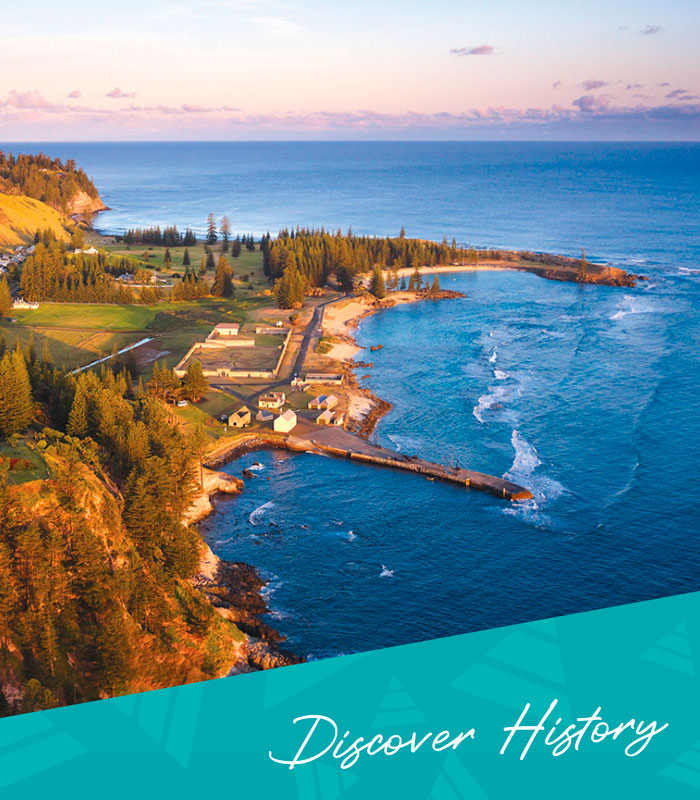


Kingston’s Old Town: Outpost to World Heritage

Huddled around the pier, where winding lanes lead away between crooked buildings, out across the common and over the hills up-country, sits Kingston’s Old Town. Higgledy-piggledy, organic, grown, the Old Town is reminiscent of a Cornish fishing village looking out to an oft’ stormy sea from under the towering embrace of Flagstaff Hill and the rugged, eroding cliffs that encircle Norfolk Island.
Kingston is Norfolk Island’s capital, the second-oldest modern colonial capital in the South Pacific. Only Sydney is older. Kingston falls naturally into several quarters that reflect its growth over the past 233 years. The oldest of these is the Old Town dating from the late 18th century. In comparison, the New Town along Quality Row with its elegant Georgian buildings and knife-edge streets is an 1830s newcomer.
The Old Town sits in the south-western corner of Kingston, anchored in place by the Pier that provides the very reason for its birth and location. It was here, between the pier and the cliffs, in an area now edged by a rocky sea wall, that landfall was first made on the 6th March 1788 by a party of soldiers, settlers and convicts under Lieutenant Governor Philip Gidley King.
Their little ship HMT Supply, a mere 21 metres long and six metres wide, carried 23 passengers from Sydney Cove. It had arrived in Botany Bay with the First Fleet in late January 1788 with 50 people and supplies. Governor Arthur Phillip had strict orders to occupy Norfolk Island, and only a few weeks later on the 14th February the Supply sailed for Norfolk Island. Two weeks later, after finding and naming Lord Howe Island en route, Norfolk was sighted. The ship spent another week sailing around the Island looking for a safe landing place. Eventually, King and his party were put ashore on a sandy beach at the end of a passage through the reef, and the British colonisation of the Island began. That day, 6th March, is remembered every year with a re-enactment and a public holiday as Foundation Day.
As King began to develop the settlement its layout reflected that of other coastal villages on rocky shores that many of the settlers were familiar with. Although King had been born and raised in the Cornish town of Launceston, some 20 kilometres from the sea, his layout of the settlement reflected its English origins. The town was fairly compact, with the larger buildings in the area between the landing place and Government House, and a hospital and several cottage-lined lanes running off what is now Bay Street in the area now covered by the New Gaol ruins. A major change to the town took place in 1804 when the third (and present) Government House was built on Dove’s Plot Hill, well away from the town but still close enough for its presence to be visible to any of the townsfolk.
Just as the town grew in a rather organic way, so its name also evolved haphazardly. A map of 1796 is titled ‘Plan of the Town of Sydney’, reflecting a name bestowed by King. He called the broad embayment in front of the town Sydney Bay, and the hill above the town Mount George in honour of King George III. In a similar vein, Governor Arthur Phillip RN, a London born Hampshire squire, had named the bay over which his Government House presided Sydney Cove, and within a few years this was also known as Sydney.
The two Sydney towns co-existed for some time. Sydney (Bay) was also locally known as the landing place or the settlement, but a visitor in 1835 wrote that it was now named Kings Town to avoid confusion with the, by then, far better known capital of New South Wales. In common talk and writing Kings Town became Kingstown, and then Kingston. Whether the place was ever officially named as such remains unknown. The name probably commemorates the town’s founder, Philip Gidley King, rather than any of the male sovereigns who preceded Queen Victoria. When the Pitcairners arrived in 1856 they came to call it simply ‘the town’ and eventually daun’a taun (down town).
As the town developed between 1788 and 1814, its growth occurred in two main phases. The town really took shape around the landing place and along the beach between 1788 and 1796 under King including the building of the hospital and hospital garden in 1794. A second wave of building between 1800 and 1804 under Lieutenant Governor Joseph Foveaux produced a stout Gaol near the landing place and the present Government House, as well as a number of new roads, bridges and seawalls. Foveaux was succeeded by Captain John Piper just as orders from London to close down the Island began to be implemented. Piper spent six years on the Island as argument over whether to maintain or close the settlement flew back and forth between London and Sydney. Although not a period conducive to developing the town, Piper had a new boat shed built in 1808. Piper did not support the decision to close the settlement, and building the new boat shed sent a defiant message to the Rum Rebel authorities that had recently overthrown Governor Bligh in Sydney. However his defiance was ultimately futile and the boat shed was the last major building work in the town.
Piper was the last Lieutenant Governor of Norfolk Island. He was replaced by Lieutenant Tankerville Crane of Governor Macquarie’s own 73rd Regiment of Highlanders with the title of Commandant and Magistrate, and clear orders to finally close the settlement. The four years of Crane’s regime were marked by the steady deportation of settlers and their property to either Van Diemen’s Land or New South Wales, the decline of the town and the abandonment of the Island’s country districts.
The darkest days of the town came in the late summer of 1814. A gang of thirty convicts and their guards rounded up the last of the cattle, sheep and hogs, and killed and salted them for the deported settlers. The last two remaining settlers, Thomas Ransom and William Hutchinson, had the melancholy duty of setting fire to all the buildings. They both arrived on the Island as convicts, served their time, and become leading citizens of the community. As they sailed away on the Kangaroo on the 28th February 1814 from Sydney (Bay) for Sydney (Cove) they left behind a scorched and silent town, populated only by the dogs that had been left behind to devour any remaining stock. This apocalyptic destruction is said to have been necessary to deny the Island to Britain’s imperial competitors, especially the French. It is a bleak irony that only weeks later, Napoleon was defeated by the Allies and abdicated his throne on 11th April.
On history’s stage this could have been a final curtain call. However, it turned out to be simply an intermission. On the 6th June 1825 the cutter Mermaid and the brig Brutus anchored off Cascade Bay. Captain Richard Turton of the 40th Regiment disembarked 50 soldiers, 57 convicts, six women and six children. One of the old settlers also returned as a guide, and the next day they marched along the overgrown Cascade Road to the ruins of Kings Town.
The town was covered by grass over two metres high, and it took them some time to find the streets, chimneys and other ruins of the stone buildings. Captain Turton reported back to Sydney that large numbers of goats and pigs were everywhere, and that the town, although in ruins, retained plenty of stone walls that could be reroofed and rebuilt, even for temporary uses. The convicts included a group of mechanics from Port Macquarie, brought over for their building skills. Along with building the town, other convict labourers were set to work bringing the gardens and fields in Arthur’s Vale and Longridge, back into production.
Buildings were re-roofed, repaired, repurposed and some re-named. Over the proceeding years some were demolished as part of a later more conscious modernising of the town. The Royal Engineers had gradually laid a new town plan over the old layout in the late 1820s, slowly developing New Town. Bay Street and Quality Row provided straight east-west thoroughfares, connected by the straight north-south lines of Pier, Bounty and Bligh streets. The new street pattern shifted the focus away from the Old Town to the New Town, with its kerbed roads, multi-storied buildings, verandah’d villas and new cemetery.
The Old Town around the landing place, where between 1839 and 1847 the stone pier and sea walls were built, survived as a heavily guarded utilitarian quarter for storing boats, receiving stores, holding departing convicts in stockades, port offices and the new hospital. This modernising of the townscape became more pronounced when control of the Island was transferred from New South Wales to Van Diemen’s Land in 1844.
One of the Vandemonian commandants, John Price (another Cornishman), gained a reputation for barbarous treatment of the convicts between 1846 and 1853. Price, it seems, also wanted to reshape the town. In 1848 he had the Bakehouse demolished because it was a “most objectionable impediment to the general uniformity and appearance of the locality”. The next year the Old Gaol was demolished because it was one of several “useless, condemned and unsightly buildings”. By the time the Pitcairners arrived in 1856, the Old Town was barely visible, an unruly little quarter almost lost in the shadows of massive two, three and four storied stone edifices connected by long straight roads.
There is a view that nothing or very little survived the 1814 burning. The present-day focus has been on the New Town, with its impressive design and scale. Now, historians are showing that we have to look closer, go beyond the surface architecture, re-examine the historical documents, the structures and landscapes of our heritage sites. They are asking questions about our origins, about what survives of those earliest days, and they cast long shadows.
The Old Town is really the 18th century creation of King, Foveaux and Piper. The plan of the town reflects their common origins in time, and the invisible baggage of their founder’s associations with Cornwall, Devon and Hampshire. It has survived burning, abandonment and rebuilding.
The Royal Engineers laid their modern 19th century Roman-style grid plan upon the landscape, creating a spacious and impressive New Town. They designed the large buildings and broad avenues drawing upon decades of military planning throughout the expanding British Empire. The Old Town pokes out rather uneasily from the south-western corner of that grid, a softer, rounded collection of lanes and small buildings draped over green sward and bounded by cliffs and the sea.
The Old Town reminds us of an earlier era, and as an historic place it allows us to let our imagination envisage alternative futures that might have been. It encourages us to ask questions, to understand how the town we see today came to be, to know who were the men and women whose decisions made it so.
Kingston’s Old Town, in its layout and surviving structures, is the oldest 18th century townscape in Australasia where the discerning visitor can still catch a glimpse of the 1790s -1800s. The distant past is not so hidden in this most antique of our capitals. The Old Town survives, waiting to be revealed again, and that alone makes it a living treasure of national and world significance.
____
First published as – ‘Kingston: One of the South Pacific’s oldest Colonial Towns – 2899 Magazine, Vol 2 Iss 2, 2010. This version is reworked and published with kind permission of Dr. Bruce Baskerville.
____
Image Credit: Robin Nisbet
www.robinnisbet.com
____
Article content disclaimer: Article first published in Discover Norfolk, Volume 05 Issue 01, 2021. Please note that details of specific travel, accommodation and touring options may be outdated. References to people, places and businesses, including operating days and times may be have changed. References to Government structure and Government businesses/entities may no longer be applicable. Please check directly with businesses and/or Government websites directly rather than relying on any information contained in this article before you make travel arrangements.