


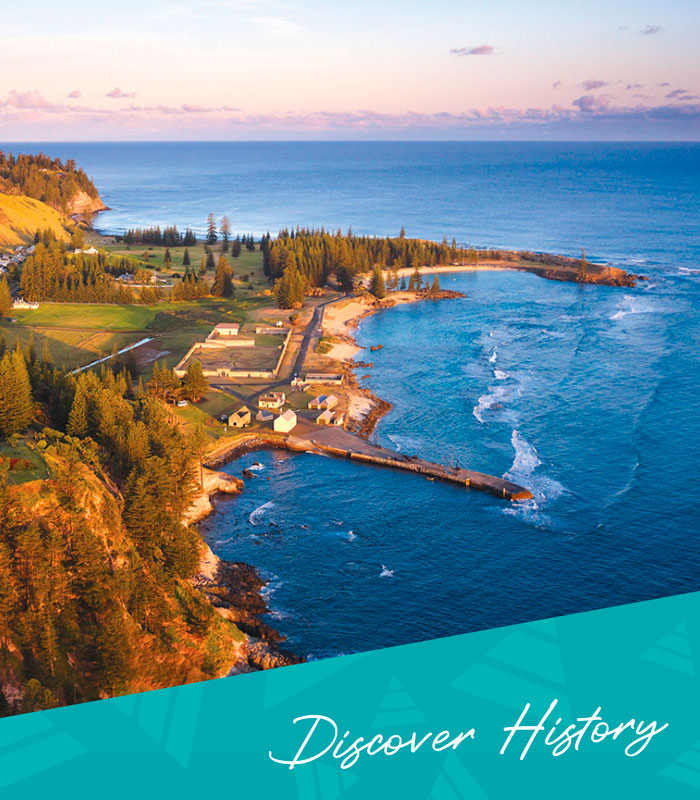


The Kingston Pier

In March 1788 a small party of convicts and marines under Lt Phillip Gidley King was sent from Sydney Cove to settle Norfolk Island. HMT Supply sailed around the island for nearly a week, looking for a landing place. King was beginning to despair. He wrote in his journal on 5th March,
“The only prospect which was to search if a passage could be found through the reef which runs along Sidney Bay (which is ye name which I give to ye Bay in ye SW side of ye Isle) we went there and ye master was sent in ye boat to examine it & on his return he informed us that a landing was very easy as a small break of ye reef (large enough to admit two boats) was formed between 2 parts of it & boats might land on a sandy beach. On his report, Lieut Ball & myself went to explore it & found it just as he had reported it. We landed on a fine sandy beach or bay without any difficulty whatever – above this beach lay a bank ye edge of which was surrounded by ye large kind of iris, on passing through it we found a fine piece of ground … here I resolved at once to fix … as it was very late in ye evening we returned on board.”
This is the earliest written description of the Landing Place.
King then described the next day,
“6th March at Day break I left the Supply with 2 boats, having in them all ye people belonging to ye settlement (except ye women)… which we landed with great ease…” The next day presented a different view “It blew so very hard all day & so great a surf that no boat could land this day.”
Thus began a recurring theme in the history of the Landing Place. For 60 years this was the main point of arrival and departure on Norfolk Island, despite its unpredictable weather and fickle location. In 1790 the Sirius was wrecked on the reef, and by 1805 when the Hannah & Eliza arrived, whaling vessels were already regular callers in the harbour. Around here grew the Old Town of Sydney Bay or Kings Town. But then something unexpected happened. On the night of 8th May 1834 a tsunami flooded into Sydney Bay and rapidly inundated much of Kings Town around the landing place, causing significant damage to the buildings and the area and changing things forever.
Between 1825, when Norfolk was re-occupied after being abandoned for some years, and the tsunami a decade later, the west end of the Old Town around the landing place had been the main quarter to be rebuilt. Many temporary and ‘light’ buildings of timber and thatch were erected, often on the foundations and alignment of older buildings, with a variety of residential, storage and other uses. Following the tsunami, many of these were abandoned or removed, leaving the newer late 1820s stone buildings used as the Pier Store and the new timber Surgeon’s Quarters on the rise behind the pier. The western side was largely abandoned in response to the tsunami, and new permanent stone buildings, also constructed partially on old alignments and foundations, were then developed on the eastern side of the landing place during the 1840s and into the early 1850s.
This ‘port quarter’ was built using some of the Old Town stone buildings such as the Guardhouse and the Double Boatshed (seaward side). New buildings were also built in stone. Their uses related to port and security functions, and included a Police Office (now the Single Boatshed) and the Guard’s balcony or sentry post on the end of the Pier Store, as well as boatsheds on the western side of the Pier Store, and the Royal Engineer’s Office. The only notable timber structures were three stockades near the Police Office and visible from the sentry post that were used to hold convicts that had either just arrived on a ship or were awaiting shipment back to Van Diemen’s Land or New South Wales. A blacksmith’s shop was also built in this area to be close to the stockades for quickly fitting or removing chains and irons.
The building of the pier, which began in 1839, stimulated the building of the port quarter and its more specialised uses. Designed by the Royal Engineers, notably Lt Henry Lugard and RG Hamilton, construction proceeded during low tides and followed the western edge of the reef. It was intended to curve around to a large coral outcrop, but the strong surf during construction constantly washed away foundation blocks of stone, and work stopped in 1847 at its present length. Metal clamps were used to fix the blocks together (another reason the old blacksmith shop and stoneyard was close to the pier), and the upper stone courses are keyed together using blocks perpendicular to the other stonework. The eastern face was built with sloping walls to try and redirect the kinetic energy of the waves away from the structure, and the interior was filled with stone rubble. Most of the labouring work was performed by the Gaol Gang (i.e. prisoners held in the gaol for offences committed on Norfolk), supposedly working up to the armpits in water while wearing heavy chains, although how they were able to work with heavy stone in such conditions is unclear.
A timber slipway built in the 1830s was replaced in 1853 with the stone slipway for launching boats. n 1855 the slipway was badly damaged in a storm, and had to be repaired. The eastern stone seawall was built prior to the pier with an opening left in it, and was then joined to the pier, but a similar western sea wall was then demolished and apparently used to extend the eastern sea wall around the new blacksmith’s shop and stoneyard.
Construction of the pier changed the layout and land uses in the Old Town quarter of Kingston. It was a major engineering and infrastructure project that lead to general renewal of the area. Its more specialised land uses changed the landing place into a port. The ‘Port of Kingston’ became an imperial town, part of the Empire-wide shipping highways. it increased the specialised character of the penal settlement’s quarters, but retained fine grain of the Old Town townscape in contrast to the Roman grid style of the Royal Engineer’s designed New Town along Quality Row and Bay Street. The stores, stockades, blacksmiths, stoneyard, police and guard outposts all indicate the main business of the port – the transportation of convict cargoes, and the need to maintain high security levels around such cargoes.
Despite the security, escape attempts and smuggling were an integral part of the port. A practice was described in 1846 whereby joiners and cabinetmakers working in the Carpenter’s Shop, further along Bay Street, made ornamental writing desks, cigar boxes and so on from native timbers. These were clandestinely traded with the boat coxswains for sale to crew and passengers on ships moored in the bay, and also used to smuggle tobacco and other goods into and out of the island. Escape attempts were numerous, such as the convicts who overpowered another group of convicts waiting to take some officers fishing, and rowed across the bar and into the open sea. Lt Lugard and two boatloads of soldiers gave chase and when they started to fire on the escapees, they surrendered and were made to row all the way back towing the two boats of soldiers. Such clandestine activities were favoured by the quarter’s Old Town layout of narrow lanes and angled buildings, especially when enveloped by darkness and clinging sea mists. A more pragmatic factor is revealed by Commandant Anderson’s complaint in 1839 that the town had become,
“…more like a trading port than a penal settlement.”
In 1846 Magistrate Robert Stuart visited the island and reported back to Hobart Town on many things, including the conditions in the port just before completion of the pier:
“King’s Town’, the head quarters or principal station, is situated on the… shore of Sydney Bay, and little above the level of the sea… A coral reef prevents the near approach of vessels to the settlement; and, as the anchorage is insecure, loading and unloading ships are tedious, being effected by boats, and crossing the bar, over which a very heavy surf generally rolls, I attended with great danger, as well from the surf on the bar, as from the intricacy of the passage, to avoid being thrown on a ledge of rocks immediately in front”.
Storekeeper Thomas Stewart described the sudden changeability of the seas around the new Pier in a description written in October 1855:
“The barr was pretty smooth in the morning, I hoisted the red flag at the jetty F.Staff and the Ensign at G.H. F.Staff, and immediately after breakfast set out to the nearest point of land to ascertain for certain if it was the cattle ship… I could see the boat making for shore, hurried down to the jetty, but found the barr had become at times very rough, and at one of these times Capt. Raymond was within half a mile of the shore, but could not come nearer, turned and went back to the ship.”
In June 1856 the Morayshire hove into view from the Pier, carrying the new settlers from Pitcairn. The emigrants were not very impressed. Their leader, the Rev. Nobbs, wrote that they were:
“…very much disappointed with its [the island’s] appearance… a succession of hillocks and shallow ravines covered with short brown grass, but scarcely a tree to be seen. Every face wore an expression of disappointment.”
The Reverend does not mention the pier or landing place, but his wife Sarah made a passing reference to it in a letter she wrote a few months later:
“[We] land on… June 8th, amid squalls of rain, which thoroughly drenched us.” Despite his first impressions, by the end of that month Nobbs was writing of the island as a ‘goodly heritage’. The inventory of buildings and structures that were to be transferred to the Pitcairner community after their arrival included, “Boat run, pier, etc., Stone pier running into the sea, with 2 flights of stone steps for landing, stone slip for launching boats, flagstaff, with stone work around the bottom”, as well as the port’s two 15 tonne launches and three whale boats.
During the 1860s and 70s, the pier witnessed the arrival of the Melanesian Mission and the comings and goings of its staff and its students from islands to the north, as well as many visits by the whaling vessels that continued from the convict era. By the 1880s and 1890s the port quarter around the pier had become a hive of whaling activities, and Kingston had become one of the South Pacific’s whaling towns.
There are many newspaper reports of whaling activities around Norfolk during the 1880s and 1890s, with whaling ships coming and going, trading with the Islanders, and of many occasions embarking or returning Norfolker crew members. Apart from the opportunities for adventure, travel, trade and income, another attraction may have been revealed when the American whaler Canton called at Pitcairn Island in 1881:
“…as she had a boat’s crew of Norfolk Islanders on board, there was a joyful meeting. Souvenirs and letters were bought from thence, which report domestic matters generally…”.
The Americans often holidayed in Kingston, and in 1889 Tasmanian emigrant Isaac Robinson was appointed as the United States consul on Norfolk Island. In 1900 the consulate was one of the places that flew its flag to mark the anniversary of King’s landing in 1788. The consulate was located in the old Surgeon’s Quarters above the Pier, with a commanding view of all commercial activities around the pier and the port quarter including the whaling companies’ boatsheds, boiling pots and quarters. This was a strategic location for a foreign consulate, and as United States influence expanded across the Pacific through Hawaii and Samoa, it is not hard to imagine concerns in Sydney and London about American intentions on Norfolk during the 1890s when planning a new undersea telegraph cable to connect the Empire. Was the Empire port town in danger of following the example of Honolulu or Pago Pago?
Whether the Pier was a scene for imperial intrigues, the 1896 return of Norfolk’s administration to New South Wales was followed by substantial investment in Norfolk’s infrastructure. Major repairs were undertaken on the pier in 1897 and 1898 to replace facing stone and rebuild the slipway. The town was surveyed in 1904 with a town plan being drawn up showing lot boundaries and street names. The newer Bounty Street, Pitcairn Street and Bligh Street, recalling an older British Pacific heritage, joined the older Pier Street and Bay Street. The opening of the Pacific Cable Station at Anson Bay in 1902 brought Norfolk firmly back into the imperial fold, although it was well away from the any prying eyes down at Kingston.
The whaling town was still evident in the early 1900s when Miss Florence Coombe came ashore, bound for the Melanesian Mission School at St Barnabas:
“There is no harbour, and in the winter it is impossible for boats to get to land… We have anchored on an early morning in September… Now the first whaleboat is put off from the shore. In a few minutes a handsome, swarthy, bare-footed Norfolker, in shabby clothes, and a home plaited straw hat in his hand, is bowing before us with the grace and dignity of a Spanish nobleman, and in a soft, quaint drawl he bids the strangers “We-elcome to No-orfolk I-island!”… very soon afterwards, when the whale-boat has been crammed from stem to stern with boxes and packing cases of all sorts, you find a somewhatrickety perch atop a huge row of stores… the process of landing is not to easy, for these green rocks are as slippery as ice, and unless you are ready to jump at the moment the word comes, the opportunity is past, and a leap would be into the sea, instead of onto the land. But don’t look around at the boiling surf.”
In 1907 a whaling boat was setting out from the pier when it was capsized by heavy surf. Another boat was launched to rescue the crew, one of whom, Tilly Adams, was badly hurt and the capsized boat was smashed to pieces on the rocks beside the pier.
As petroleum oil began replacing whale oil, the use of the pier declined, and by 1914 when a visitor to the island described a fairly typical landing at Kingston there was no mention of whaling boats:
“October 7th. The great event of the Island, the arrival of the monthly steamer from Australia, drew us, with the rest of the population, to the landing place, which this month was the ‘Town’ the wind being favourable… the familiar old ‘Makambo’ casting anchor on its none too smooth anchorage, two big row boats struggled off through the heaving surf to meet her, well before she got in and a long delay again before the medical inspection was over and the few passengers came ashore kept the crowd of Islanders intently watching and waiting. The scene was like a huge country picnic… every inhabitant of the Island, apparently, waiting to receive this one connecting link with the outside world.”
In 1914 Norfolk Island became Australia’s first external island territory. New opportunities for customs and duty-free trade with the mainland opened up, and the export of lemon juice, passionfruit pulp, bananas, oranges and other sub-tropical produce and fish boomed. Every visit by a ship to the pier attracting the increasingly organised carrying of casks of produce by the island lightermen, utilizing skills and lighter designs descended from both the whalers and the boats left by the convicts.
The Pier’s 20th century history is as rich and varied. By the 1920s when whaling resumed, it did so in Ball Bay, well away from the Pier and Kingston. World War II brought dramatic changes as Kingston again became a military garrison, with extensive gun emplacements and other defences overlooking the port and a steady stream of military transports to the Pier unloading heavy machinery and personnel. Ironically, it was the war that ended the Pier’s pre-eminence as Norfolk’s gateway to the world. All this wartime activity lead to the
building of the aerodrome and the development of the new town of Burnt Pine. The post-war focus has been on the development of air transport and air services. Cargoes still arrive by ship and are unloaded by the local lightermen, and the occasional cruise ship and passing yacht calls in, but the Kingston Pier is now more the haunt of fishermen, tour guides, swimmers and strollers rather than the regular commercial uses of the convict transports and whalers.
The Pier had a brief moment of royal glory in 1974 when the Queen made her first visit to Norfolk Island. The visit was well covered by the Women’s Weekly, with a picture-spread titled “Queen Shoots the Waves” showing the launch from the royal yacht Britannia almost lost in “…cyclone sized seas” as it approached the pier, and then showing the Queen on a wave-soaked pier meeting local dignitaries… After nearly 140 years, the adventure of landing on Kingston Pier had not abated.
Visitors today can still inspect the original stone walls of the pier, patched and repatched by many succeeding generations, still see the waves crashing over its embankments, still feel it shudder with every crash, still watch boats being lifted over its sides into and out of the sea, still watch a ship being unloaded, still witness the annual Bounty Day re-enactment of the Pitcairner’s migration in 1856. There are plenty of spots to sit and take in the patterns of the reef, the colours of the landscape and the views back towards the town, or just feel the salt spray or experience a glorious sunrise or sunset.
There are also plenty of spots just to let the imagination run wild and see once again those earliest settlers on a virgin beach, or the prisoners in the stockades awaiting shipment, or struggling in chains on the fruitless task of trying to extend the structure, or a large whale being brought in by men in small boats for the bloody rituals of flensing, or glimpses of smugglers and spies vanishing around a misty corner, or intrepid travellers clutching skirts and hats as they leapt from rocking boats onto slippery steps to be caught by strong arms and welcomed with lilting Pacific accents. Miss Bertha Murrell wrote in her tour journal in 1915, “In the days of its youth Kingston must have been quite a little town.” Kingston Pier still provides shelter for memories of that little town, and many more.
____
Image Credit: Robin Nisbet
www.robinnisbet.com
____
Article content disclaimer: Article first published in YourWorld, Volume 01 Issue 02, 2011. Please note that details of specific travel, accommodation and touring options may be outdated. References to people, places and businesses, including operating days and times may be have changed. References to Government structure and Government businesses/entities may no longer be applicable. Please check directly with businesses and/or Government websites directly rather than relying on any information contained in this article before you make travel arrangements.